Maps of the Middle East

|
Iraq - Large Map - Roads, oil pipelines, oil fields, ancient sites, land use areas, towns, and provincial borders. |

|
Iraq Demographics - Ethnic and religious groups, population density. |

|
Baghdad - An aerial photo with hospitals, universities, mosques, and the "Green Zone". |
|
|
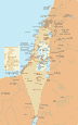
Israel
and the Occupied Territories - Israel, West Bank, Gaza
Strip, Golan Heights, Israeli settlements, refugee camps, province borders,
towns, railroads, and pipelines.
|
|

|
Gaza
Strip 2003 - Built-up areas,
refugee camps, roads, settlements, Israeli military areas and the Israeli
perimeter security zone.
|
|
|
West Bank
2003 - Built-up areas, refugee camps, roads,
settlements, Israeli military bases, checkpoints and roadblocks, military
controlled roads and the partly constructed separation fence.
|
|

|
Greater
Jerusalem - Built-up areas, roads,
settlements, Israeli military bases, boundaries of New City, Old City and
planned UN mandate for Jerusalem, checkpoints and roadblocks, Israeli
bypass roads and the partly constructed separation fence.
|
|
|
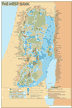
Israeli/Palestinian
Water Systems - Wells, pipelines, pumping stations,
reservoirs, desalination plants and the Jordan River watershed.
|
|
|
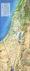
The
Middle East - Petroleum Systems Map - Oil and
gas fields, oil and gas pipelines, refineries, export terminals and US
military facilities.
|
|
 |
Map of Afghanistan |
 |
Stunting - National
percentages for the stunting of children under age
five. |
|
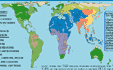
Map of World
Religions
|
|
|
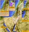
NEW!
Palestine
in Biblical Times - Ancient towns, the route of the Exodus from Egypt, the conquest of Canaan by Israel, Palestine under Greco-Roman control, Palestine under Arab Caliphs, Palestine during the period of the crusades and Palestine under Turkish control.
|
|
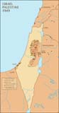 |
Israel/Palestine 1949
- Israel after the 1948 war, and the 1949 Armistice
Green Line. |
|
 |
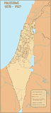
Palestine
Under British Mandate 1923 - 1948 |
|
 |
Proposed Partition
Plans 1937 - 1947 - Royal Commission, British,
Anglo-American and United Nations. |
|
|
Palestine 1878 -
1927 - Palestinian villages and
towns, mixed towns and Zionist settlements.
|
|

|
1916 Sykes Picot
Middle East Partition - Zones of influence and
control and dates of independence for Middle Eastern countries.
|
|
 |
Middle East 1914
- Areas of British, Ottoman, and
Russian control and influence. |
|

|
Jerusalem's
Old City - Moslem, Jewish, Christian and Armenian
quarters, gates, and sites of religious significance to Judaism,
Christianity and Islam.
|
All maps copyright The
Knowers Ark Educational Foundation. All Rights Reserved. For information about
using any of these maps, please email.
Please click here to view our selection of links to other sources of maps of the Middle East.
|