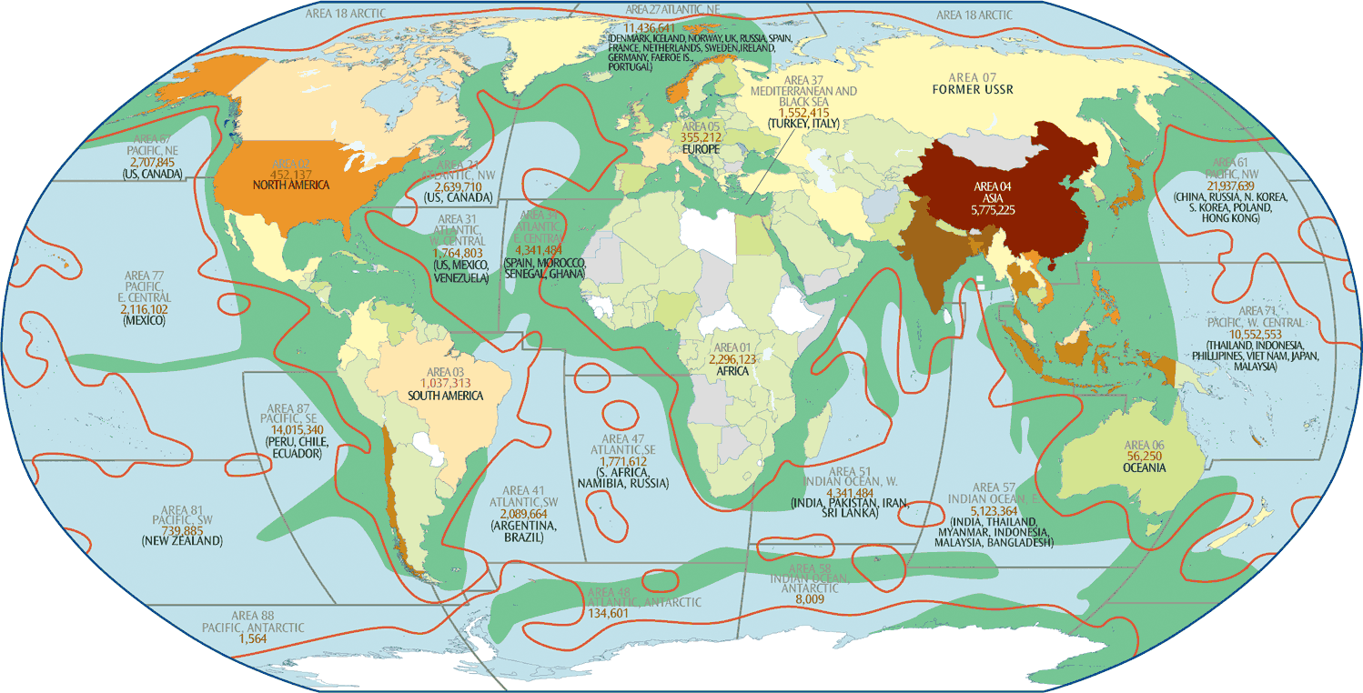
Map of Global Aquaculture and Fisheries

Each coastal country has an EEZ extending 200 miles offshore. “99% of the worldwide annual commercial ocean catch comes from coastal waters... these narrow coastal fringes are both the most productive and the most vulnerable.” Legal mechanisms and investment incentives are being implemented to privatize and develop these marine areas for open ocean aquaculture–exploitation that is beyond state or provincial regulation. Areas where an ice shelf extends beyond the coastline are also a source of potential dispute.
2005 version of this map
More Fishing & Aquaculture Infographics


Sources
EEZs and FAO FISHING AREA BOUNDARIES: United Nations Food and Agriculture Organisation, www.fao.org/docrep/U8480E/U8480E0f.htm
CAPTURE AND AQUACULTURE PRODUCTION:
UN FAO The State of World Fisheries and Aquaculture 2018 and UN FAO Fishery and Aquaculture Statistics 2019; www.fao.org
Global Capture Production, 1950-2017 (FishstatJ), updated 2019. www.fao.org/fishery/statistics/software/fishstatj/en;
UN FAO Department of Fisheries and Aquaculture: World Development Indicatores; data.worldbank.org/indicator
PHYTOPLANKTON: Phytoplankton Production”; Gaia, An Atlas of Planet Management, globalchange.umich.edu/globalchange2/current/lectures/fisheries/fisheries.html
TEXT: [1.] UN World Water Development Report, www.unesco.org/water/wwap/wwdr/index.shtml [2.] IUCN: Species Susceptibility to Climate Change Impacts; iucn.org/downloads/climatic_c; [3.] World Summit on Sustainable Development 2002, “A Framework for Action on Biodiversity & Ecosystem Management”, www.johannesburgsummit.org/html/documents/wehab_papers.html
Tags: fisheries, oceans, overfishing, coral, aquaculture, eez, global aquaculture and fisheries, fisheries-and-aquaculture
Sign up for EARTH Dispatches
Enter you email below to get jaw dropping charts and maps delivered straight to your inbox.
Get the EARTH presentation
A 150 page high-resolution PDF containing all updated maps, charts and data on EARTH website; use as an information-packed educational slide show, printed booklet or a set of single-page handouts.
Learn More